I bought a great 'back roads' and topo maps atlas for Arizona this year and found it to be a great asset in finding new places and exploring off-highway areas.
So as soon as I got to California, I started to search for the equivalent. I found one, though not from the same company as the Arizona version.
From Pismos Beach, I looked for a change of scenery on the trip north. The map showed this great looking coastal road, so I thought I would give it a try.
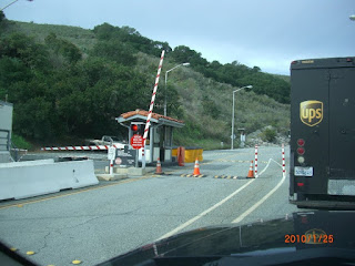
Except when I got to the junction, there was this very official looking security gate! Undeterred, I ventured to the gate to see what it was all about. After all, I had had to pass through a military security gate last year when passing through the Hunter-Leggett road back to the coast. I thought that it was perhaps the same here. Well, the (private) security guard was evasive on the reason, but said that I could not go on the road. Eventually, he told me that it led to a nuclear power plant! Now I get the picture. "Tomtom, where to now", I said.
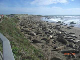
The coast was eventually reached again and it went north of Cambria, and the Hearst Castle (which we had visited in March last year), and past the Elephant Seal beaches. Some were closed to public access like this one,

but others had the designated viewing platforms where you can actually get plenty close to the animals, but without disturing them - or getting eaten. Which is a good thing. Unlike the smells and the sounds.

There was no snow for them to play in, but it appeared their favourite activity, next to sleeping and grunting, was to throw sand in each others faces!
I also stopped to check out the State Park Campground just north of Cambria. I'm pretty sure when I stayed here last year the price was 20 dollars? This year the price was 35, and the campground was - empty. Sounds like an obvious cause and effect to me?
Sorry, but my dollar sign key on the laptop is broken! I can use the other 4 on the number pad, but there is no other dollar sign! I guess I could find one somewhere else and use cut & paste?
Gosh, this blogging gets tough some times.
Incidentally, before I forget, it appears that several states down here are in severe financial crisis. It is so bad in Arizona that they have closed many of their highway rest areas, and are planning to close about 20 of 27 State Parks this summer.
Back on the road, it was witness to the neverending battle between CalTrans trying to attach roads to sheer cliffs and slumping mud banks, and nature, trying to return it all to the sea.
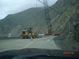
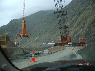
I had just passed by one of these major projects, when a large chunk of sharp rock about a foot in diameter fell and came to rest on the centre line of the highway in front of me. No time for a photo, but I quickly got out and moved it off before some unsuspecting little car came around the corner and got launched into the ocean.

I watched the rocks from above as I did so, recalling the time back at work in Yoho National Park when perhaps a hundred tons of rock, mud, and trees had come down such a bank at me - onto the Trans Canada highway, which was open for traffic at the time. Needless to say, I closed the highway that time. But this time I saw a few more pebbles and small rocks coming loose in the rain, so I wanted to get well down the road before this one was closed as well.

At the point Sur Lighthouse, security was also (apparently) paramount.
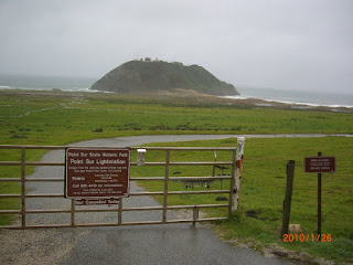
After all, you would not want someone taking in an unathorized view! Check out this line of padlocks! In their defense, they do give tours.

And this 'security guard' was demonstrating on that poor little bush what he would do if someone climbed the fence without authority.
Carrying on into San Francisco, some riders were out enjoying a ride on the beach.

No mention of horses being swept away, so I guess they were OK!
I avoid most of the main roads in San Fran, and sneak up to the Golden Gate from the west side - much more scenic that way.

And took the obligatory photo after crossing over. No tolls when northbound!

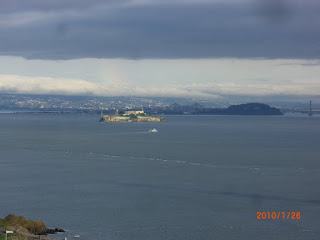
And no photo of the Bay area would be complete without at least one photo of Alcatraz. We took the boat tour right past it in March!
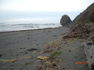
And once again northward, to a secluded little ocean-front spot I have utilized quite a few times while travelling through here. It has it's own little resident group of seals who hang out across the river mouth on a sand bar.

If memory serves me correctly, the beach has changed here a lot in the past couple of years. This chunk of beach used to be a lot larger, and had tons of driftwood stacked on it. I guess the winter storms have taken their toll and moved things around quite a bit! And once again the crab (?) boats were out just offshore working through the night.
Whew, that's enough for today ....
 I found myself a small backroad to explore as I left Willits, Oregon.
 But then it got interesting!

 Narrow (very narrow in places), water covered,
 one laned,
 clinging to hillsides above creeks and little bridges,
 under overhanging canopy of branches, in some places almost dark.
 There were a few residents along the road, watching the silly tourist.
 Till eventually the little track leads back down the to the main highway.
 And then into the Redwoods National and State Parks.
 Where the trees are tall and the sunlight barely finds it's way through. Same thing for satellite radio signals, tho Sirius is way better than XM for that I have found.
 Then, on the way out to my oceanfront camping spot, there was a goat on a 'goat house'.
 And some cows lining up for the evening milking time.
 And, some more water on the trail!


