Thursday, October 25, 2007


Found a couple of photos on the cutting room floor that were missed from the last post. These were taken on the beach at Kokanee Creek Provincial Park on the West Arm of Kootenay Lake.


The park is 19 km east of Nelson, and 15 Km west of Balfour. The park provided a welcome overnight stopover after a visit to Ainsworth Hot Springs further north.

I also took some photos of Columbia Lake near Canal Flats and some of the signs at the highway viewpoint. I was pleased to note that all the photos on the "Friends of the Columbia Wetlands" were credited to Hans Fuhrer, who I used to work with at Kootenay National Park.


It was dark when I reached Lussier Hot Springs, which is now within Whiteswan Lake Provincial Park, so I did not take any photos of the actual springs, but through the wonder of the modern internet, I am able to provide you of a daylight shot of where I sat enjoying the stars that night.


Lussier Hot Springs


On departure the next day, I took some photos along the access road. Portions of the road are not for the faint-hearted. Some sections are one-lane, with a serious vertical drop to the river below. Both logging trucks and some sort of rock trucks were using the road from about midnight on, making the one-lane cliff sections high on the pucker factor. The trucks all use two-way radios to avoid colliding with each other, but the tourists are at their mercy. I had my scanner going, so at least I knew where they were, if not vice versa. I only stopped on wide sections for these photos.


Logging road leading to Lussier Hot Springs and Whiteswan Lake Provincial Park.


On the way back through Sinclair canyon, near Radium Hot springs in Kootenay National Park, I snapped a shot of the mirror used to see around the corner in the canyon. If you click on the photo for a larger view, you should be able to see the camper in the mirror.


Highway mirror at Sinclair Canyon near Radium.


But prior to that, I parked in the village of Radium Hot Springs, where I knew there was a web cam in operation. So I got out of the truck and posed in front of it for the photo you see here.


Web cam shot of me and the camper in Radium Hot Springs village.


If you had been watching the web cam link above at the time, you would have seen me 'live'! Of course, I had the laptop in the truck and access to nearby wi-fi signal, so I was able to see this shot from the driver's seat while parked there. Pretty weird, huh? But it gets better.

Since I had wi-fi signal, and had been away from home for a few days, I decided to check my e-mail and have a look at my own web cam - which looks out my front window at home. If you've been reading this blog for a while, you will remember shots of deep snow banks and snowblowers from this cam - while I was on a Mexican beach camping for free. But I digress.
The web cam image is usually pretty static and mundane and boring. Imagine my surprise to see 3-4 people, ladders and gear sitting on my front sidewalk! Turns out they were there to clean my chimney. So, the next shot is a screen-shot from my laptop at the time, showing me in my truck in front of the Radium web cam, and my home cam on the other half of the screen - at the same time!


Screen shot of Radium and home web cam at the same time.


Web cam shot from home.


Till next time ...

Saturday, October 20, 2007

Photos of Slocan Lake at New Denver, BC. Google Maps link.


It's time for your history and geography lesson, mixed in with a whole bunch more photos from my last trip into the east Kootenays.

Canal Flats is the centre of this story, but don't even consider erasing the 'C' on their highway sign!


Canal Flats sits just south of 16km long Columbia Lake, which is the headwaters of the mighty Columbia river.
It flows for more than 1960 kilometres (1200 miles) before reaching the Pacific ocean at Astoria, Oregon. It drains a 259,000 square mile basin that includes areas in seven US states, as well as parts of British Columbia.
From it's humble beginnings at Canal Flats, it flows northward for over 420 kilometres, past Invermere and Golden, where it enters Kinbasket lake which almost reaches Valemount to the north. Then it swings southward, through Revelstoke into the Arrow Lakes (see previous post), and south to Castlegar (*), and Trail, then into the US for the remainder of it's course.

Coincidentally, the Kootenay River, which originates to the north in Kootenay National Park, flows southward right past Canal Flats in the opposite direction from the Columbia - which is headed north. It then flows southward for 200 Km into Montana, before coming back north into Canada. It flows north past Creston (home of Kokanee beer) and into Kootenay Lake before heading west where it flows to Castlegar (*), ... and joins the Columbia! So the two rivers pass within 1.2 km of each other, then actually travel hundreds of kilometres in opposite directions, before deciding to join.

That's it for geography, now for the history. Because of the proximity of the two rivers, and the importance of rivers in early transportation, a canal was constructed between the two rivers.
The canal was also part of an attempt in the 1880's to divert water from the Kootenay into the Columbia, thus lowering the level of Kootenay Lake to reclaim thousands of hectares of valuable farm land.
But the plan was abandoned after only two boats passed through the canal and lock system because of fears of flooding of the Canadian Pacific railroad and farmland around Golden.

And now for the modern portion of the story. The two rivers join in Castlegar, right by Zuckerberg island - which I visited when I passed through that area. I did not erase the 'C' on the Canal Flats sign!

So, .... I too went southward past Trail along the Columbia river, where I watched a number of modern voyageurs, in brightly coloured plastic kayaks playing in a wave just north of the border.


Kayakers on Columbia south of Trail, BC.


At the border, I turned east along the Pend Oreille river which flows out of Washington State, past a dam just a few hundred meters from the border. Though the river only flows in Canada for about 25km, there are an additional two more hydro dams in the Canadian section.

As you drive east from Waneta (south of Trail), there is a dam right where the Pend Oreille flows into the Columbia, then the next dam is the 7 mile (pictured).


Seven Mile Dam on Pend Oreille river south of Trail, BC.


When I used to live in Trail around the time of the dinosaurs, I used to come down here with my jurassic gold pan and find a few flakes in the tributaries in the area.

A large forest fire came out of the States this fall and burned a lot of the bush and riverbank in this area.

Fire along Pend Oreille river that came from the US.


The road has been blocked several times over the years from both natural and man-made barriers. There are two man-made barriers that have simply been covered with dirt so you can drive over!


The road ends at Nelway, which is a two-horse town that consists of a border crossing, and the two horses.


Canada Customs - Nelway, BC.


Leaving the border crossing at Nelway, the route was back east, over the Salmo-Creston summit, or Kootenay Pass as it is officially known. The pass starts at about 2100' on the Salmo side, tops out around 5823' before dropping to 1700' in Creston. If you prefer meters, click on the pass profile pic.


If you prefer a live pic from the pass, there is a BC Highways web cam to be seen - here.


Next blog entry - visit to Lussier Hot Springs and more web cams.

Tuesday, October 16, 2007

Fall has certainly arrived (in Lake Louise, at least), with frost every night if the sky is clear. I had been keeping a light bulb in the camper at night to keep it from freezing, but had given that up, drained the tanks and put anti-freeze in the water lines. But it is not this cold everywhere, so when the opportunity came to go camping again in a warmer area, it did not take much convincing to reverse the process.

On the first night, I drove highway #23 south of Revelstoke and camped in the provinciaol campsite at Shelter Bay ferry terminal.


View Larger Map


Departing Shelter Bay ferry terminal.


In the morning, I caught the free ferry to continue southward.

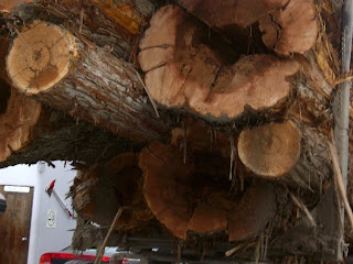
We shared space on the boat with at least three loaded logging trucks.


Backup ferry at Shelter Bay.


Load of logs on the ferry.


Big logs!


The backwoods hot spring on the St. Leon road was apparently closed, so it was decided to mortgage the farm and pay for swimming and camping at the commercial Halcyon Hot Springs!


Had a dip both evening and morning, and spent some time walking the grounds and looking at some historic buildings.

Later in the morning, during a quick stop in Nakusp for some coffee and goodies, a local cat decided he would like to join the expedition by jumping on the hood of the truck!

Luckily Harley could not get his paws on the little guy.


Cat prowler in Nakusp.


Both Halcyon and Nakusp are on the east side of the Upper Arrow Lake.

They grow big trees in some parts of B.C., but I did not know that they grew big rhubarb as well. Check out these specimens!


From Halcyon hot springs, it was then off to Ainsworth Hot Springs. Ainsworth is south of Kaslo on the west shore of Kootenay Lake in the Purcell Mountains. The natural, outdoor springs feature a unique horseshoe shaped cave that takes you into the mountainside, while wading in the hot water with 100% humidity!


View Larger Map


The cave entrance at Ainsworth hot springs.


The remainder of this trip will be detailed in the next post - and it involves yet another hot spring in the east Kootenay's.

Lastly, I have included a short video (as a test) that I made a week or so ago when taking a horse back to the ranch for the winter. I led Foxy a short distance to her winter pasture behind the truck.


Foxy and friends.

Monday, October 8, 2007


On Sept 14, Jasper became Canada's fifth national park, taking its name from the abandoned fur trading post Jasper House.

Since this occurred in 1907, 2007 is the 100 year anniversary of the park's formation.

Several years later in 1913, the railroad town of Fitzhugh as it was then known, was renamed to Jasper.

A local newspaper in town retains the original name, Fitzhugh.


Because of the centennial, it was decided to have the 'party of the century', which included a big parks staff reunion, for which I was qualified!


The weather was great the whole weekend and there was lots of colours in the leaves along the road. So I became a tourist and took some pictures to show you.

There were many special events and displays and demonstrations downtown Jasper in front of the information centre - including some wardens and pack horses.


Many of us camped at Wapiti campground, just south of the townsite, so Harley got to keep watch on a whole new crop of squirrels.


Near the 'Weeping Wall' on the Icefields Parkway.


'Big Bend', just south of the Icefields.


Athabasca glacier - Columbia Icefields


Near Athabasca Falls.


NEW!

I just found this great link to very fancy, animated website on the Icefields Parkway.
Go check it out here!


Links to Jasper Centennial:

http://www.jasper100.com/


Jasper Celebrates 100 Years


Jasper Journal