YUKON/ALASKA Roadtrip 2009Okay readers, we are about to set off on another 3-4 week roadtrip into north western Canada's Yukon territory, and the state of Alaska! This will be a first time for me.
Background: Past readers will note that most of my blogging has been more or less in real-time, with only short delays between events and their posting on the blog. This time was different, as I did not have the time or internet access available to keep up to date. I did manage to post the occasional photo direct from my iPhone, and the iPhone on occasion was able to transmit it's location on a Google map. I did however take around 800 photos on the trip, and will now hopefully be able to display a small selection of those. You will note that there is once again a cat along for the trip - but this is not Harley, of great blog fame who sadly passed away just before Christmas. This cat will be referred to as Ms S, as she is a bit of a princess. And a princess has to have a servant/care-giver along, so there was also another person along to care for the cat, but who avoided the camera at every opportunity. This person also served as chief planner, navigator, and creator of culinary excellence - a huge improvement from my usual road fare.
I have not usually been able to escape from the demands of the job for more than short periods during the warmer months, but a combination of changing attitudes and some very creative scheduling enabled me to be away for almost an entire month.
So, on Friday afternoon, after I, the cat, and the cat's servant escaped from our jobs, loaded the last things into the camper; we were off - into the sunset, quite literally. We hit highway 93 north from Lake Louise - the Icefields Parkway. Already impending fuel shortages had emptied the tanks of some fuel stations in the area, so I was glad I had filled up early in the day to be sure.
The first decision point came upon reaching Jasper and highway #16. Would we go west through Prince George and go north on the Stewart-Cassiar highway, or up to Grande Prairie and join the Alaska highway in Dawson Creek, BC? After a hasty consultation, and reading the stars and horoscopes we decided to use the latter route, and headed east. But night was soon upon us, so we invited ourselves to camp in a friend's yard near the Jasper east boundary.

Not really a coincidence, but it was also a place I had lived for several years, twice, in the 1980's.
We made ourselves at home, fought off a few mosquitoes, and had a good
nite's sleep with only moderate traffic noise. In the morning, Ms S had to go for a stroll to visit the horses in the corral.

We missed a
coffee invitation from our hosts, but headed east into Hinton and fueled up - mainly to be sure that any impending shortage would not stop our progress too early. A few last-minute items were loaded at Safeway, then it was north to
Grande Cache, across the Smoky river, then on to
Grande Prairie. Took on some more fuel in
Grande Prairie, and filled the coffee mug at Tim Horton's for the road to Dawson Creek across the line in BC. This is the start of the famed Alaska highway, so we had to stop and take a few photos of the start of the road, and the navigator/planner loaded up on pamphlets and information as well.

As you know, the highway was built in a very short period between 1942 and 1944 as a military link to help protect Alaska from the threat of invasion during the second world war.
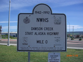

If you click on the photos for a larger view, you should be able to read these plaques!

We pushed on through Fort St John and topped up the fuel tank again. There were signs on the pumps warning of the shortage and banning the filling of large 'slip tanks' and barrels.

We kept on heading north till we got tired and pulled off around the Mile 140 mark (km 140?) near Pink Mountain. Driving down a side road, we stopped beside a small river, and made use of a fire ring for our first camp fire of the trip. Sounds of running water put us to sleep.
Camp location:
n 56 52.741 w 122 39.402
In the morning, Ms S insisted in terrorizing some local songbirds till we were ready to depart.

Next: Liard River Provincial Park and hotsprings!
 Liard River bridge - near the provincial park.
 We arrived in the early evening, but there was still a bit of room in the campground. We selected a site and had supper, but it was late and the mosquitoes were a bit 'active', so it was decided to delay swimming till morning, so we enjoyed a movie in the camper instead.
 In the morning, we got a very early start, and had the pools to ourselves for a fair while.
 The pools are natural, with very well maintained wooden walkways, stairs into the pools and change rooms and bathrooms on site.
 The pools themselves are about a 20 minute walk from the campground.
 Before visitors arrive and mix up the waters, there is a very evident temperature difference from the hot surface water, and the cooler underlying layer. It is very hot where the water flows into the pools, and we were constantly stirring cooler water from below to keep from overheating.
 Because of the size of the pools though, you can pretty much choose the right temperature for yourself by moving further from the source. As an additional advantage to the peace and quiet in the early morning was the lack of many active mosquitoes.
 After a leisurely soak in the pools, we hit the road north, and encountered a number of herds of bison grazing roadside.
 This one was obviously sporting a radio collar.


