Monday, August 22, 2011

Arrow Lakes–Driving on the rails.

After a spell in Saskatchewan, Hailey and I thought it was time to do some more touring in BC.  So we headed out west once again on the Trans Canada highway over Roger’s pass, then south of Revelstoke onto the ferry.

We soon found ourselves in the Castlegar area, and decided to check out Syringa provincial park, on the shores of the Arrow Lakes.

After a few days visiting friends and camping in the official campground, which was very quiet I must say, it was time to head out and find some more isolated locales.  From the park, I could see what I was told was an abandoned railroad grade on the far side of the lake, so when I found a forestry road heading in the right direction, I checked it out.

Unfortunately, the Shields Creek FSR ended with huge gates and ‘private’ signs before reaching the lake shore, but the old rail bed looked like it had limited potential.  It was narrow, with few if any places to turn around and the low branches looked ready to rip the kayak or the fridge vent off the roof of the camper.  But it was time to find a location to spend the night, so I took the ‘Motorized traffic permitted’ sign at face value, and bravely headed out into the unknown.CIMG6349CIMG6302

The kayak and fridge vent seemed to be surviving, and the truck did not seem worried by the vertical drops on the lake side of the trail. Then came a tunnel!  Everything seemed to fit OK.

CIMG6303

Next, we came to a high trestle with narrow railings. We tested the width, and at no point did both mirrors rub the railing at the same time

 CIMG6315CIMG6317

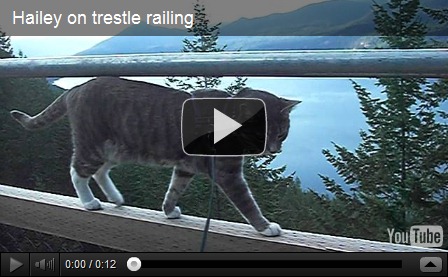
and I figured that if the trestle was built to hold trains loaded with lumber or ore (!), it should have no trouble with a truck. The map showed no reasonable ‘escape routes’ onto logging roads for miles and miles.  When there was finally a place to turn around we did so and found a wide spot next to a trestle to spend the night.  Watching the sun set from this high vantage point on the lake was spectacular.  Hailey and I had time to explore the bridge and take some photos as well.

CIMG6319CIMG6321CIMG6324CIMG6326CIMG6327CIMG6328

Hailey walking the rail.

A chance conversation that evening with another person on the route indicated that contrary to my expectations, I could perhaps drive all the way out to the main highway via this old rail bed!  So, in the morning, we continued on!

CIMG6329CIMG6302

There were more tunnels.

CIMG6305CIMG6307CIMG6308CIMG6310

There was another trestle.

CIMG6312CIMG6337

CIMG6338CIMG6339CIMG6342CIMG6344

CIMG6314CIMG6345CIMG6303CIMG6346

And one tunnel that was a half mile long!

CIMG6362CIMG6363CIMG6364CIMG6365CIMG6366CIMG6305

There were lots of scenic viewpoints, and a couple of primitive campsites.

CIMG6350CIMG6355CIMG6356CIMG6358CIMG6360CIMG6370CIMG6371

There was a historical marker at the location of a mysterious explosion onboard a train in 1924.

CIMG6372CIMG6373CIMG6374

Note: At the end of the trail I found a kiosk that described the abandoned rail line as being for use by foot, horse and bicycles only!  Oops!  But then I spotted another sign saying that ‘motorized traffic’ was permitted.  Upon closer examination, I could see that the ‘no’ on the sign had been painted over, but I was not sure if it was an official change or the work of a vandal.  Clearly, I had met other motor vehicles on the way, including 7 quads the first evening.

An online search later seemed to show that there was a bit of controversy over the intended use, with intense lobbying to allow some motorized traffic.  The non-motorized lobby was concerned about vandalism and garbage if vehicles were allowed.  I did not see any sign of either.

I had also started on the trail other than the designated entrances, so I had no chance to read any information on the trail.

A bike-blogger blogs about the section of trail from the start at Castlegar that I did not travel – more good photos, too!

Sunday, August 14, 2011

Limestone Mountain Lookout

A couple weeks earlier we had been touring around the backroads in the area, and made an attempt to locate the correct road to the Limestone Mountain lookout (51.8818°N 115.422°W ).  We managed to drive almost around the mountain, but found a dead end road that was still several kilometres and a couple of deep watersheds over.

After a bit of online research we found that the correct turn-off of the main limestone road was at a sign to LM6, one of many gas wells in the area. Coincidentally, my neighbour asked me just the day prior if I knew the way to the lookout!

Although the access road into the entire area is signed to indicate the huge gate at the entrance could be locked at any time without notice, clearly it was of little concern to the many many campers and RV’s set up in random locations along the river – very nice spots, and the price is right!

Knowing the correct route made the navigation easy this time, and we found that one could actually drive right to the top of the ridge, though this is actually several kms from the actual lookout.  The last km or so gets pretty rough, and ‘city’ vehicles may wish to park to avoid getting hung up in some rocks.  My truck was felling frisky without the camper on it’s back and bounced the way up no problem.

CIMG6201CIMG6202CIMG6203

A group on quads arrived soon after us, and even brought up some wood for a campfire above treeline.  I noticed an oil leak coming from one of them, so it must have encountered one of the rocks on the way up.  That machine was loaded onto their ‘support’ vehicle for the trip down.  I was very pleased to see that after the departure of the fairly large group, there was not one scrap of litter or any other signs of their passage.

CIMG6167

When researching the route, I had discovered that there was a geocache in the area, and sure enough, my two gps led me directly to my first ever ‘find’.

CIMG6174CIMG6170CIMG6171CIMG6172

Much to my surprise, it turns out that my neighbor had found the cache just the day before.  There are a number of communications towers in this location, and from here it is still a few kms of very scenic ridgeline hiking to the fire lookout itself.  Too bad there is a line of power poles all the way as well.

CIMG6168

CIMG6177

Because of the location on top of a mountain, there is not a fire lookout tower, just a lookout on top of the tower cabin.

CIMG6180CIMG6182CIMG6184CIMG6175

We had lucked out with the weather, and enjoyed spectacular scenery for 360*.  It was sure nice to be doing some hiking in some real mountains again!CIMG6186CIMG6187CIMG6188CIMG6189

One of the local residents was out catching some rays, and agreed to pose for a few photos.

CIMG6192CIMG6194CIMG6198

I’ve been internet ‘challenged’ the last while, being on the road without my satellite gear, and usually out of Roger’s cell phone coverage.  Therefore I have not been able to keep up to date with other goings-on in the RV blogging world.  But I did notice a new addition to the Bayfield Bunch.  Welcome Eve to the fame of blog world!  Hope to meet you next winter down south!

Next post:  Back to BC – and some railroad driving.


Next:  Back to BC again!

Monday, August 8, 2011

Dear Saskatchewan, Your roads suck (big time!)

Well now, I guess we know the tone of this blog post!

But I will try to be brief, then get on to the great parts of Sask.CIMG6097CIMG6098

Dear Saskatchewan government,

Now that you are raking in millions of $ in gas and oil revenues, it is time to open the purse strings and spend at least a little money on your crappy roads!  Yes, I know that you have a small population, and lots of roads, but let’s get started.  It’s a big job. For starters, I caught a rock from a passing vehicle in the Yukon almost two years ago, and the cracks had not spread since, and totally avoided my viewing area.  Two years.  That is until I hit the first few miles of roller-coaster, pot-hole laden roads in Sask.  That was enough to send the dormant cracks heading out into fresh glass in front of the passenger side (for now). Granted, most of your main roads are in decent or even good shape, but your secondary roads belong in the third world.  Mexico would be embarrassed by some of these routes!  Some of the road seemed to change back and forth between gravel, oiled surface with potholes, and back to gravel.   At least the Mexican topes (speed bumps) are marked; not so your potholes.  But like Mexico, you could detect impaired drivers on the road because they were the ones going straight down the road, not swerving and braking like any sane sober person would do to avoid these award-winning potholes!  I saw drivers considering head-on collisions with oncoming trucks, rather than plunge into one of these car-eating holes!  There is a story going around that Saskatchewan has NO road maintenance crews.  I was ready to buy into this hypothesis, till one day – it happened!  I actually saw people dressed up, pretending to fix the roads!  Here is the evidence in this un-retouched photo.  You be the judge!CIMG6111

Dear Saskatchewan Roads department,

Have you ever heard of signs?  I know tourists and strangers are rare in some parts, but not everyone lives just down the road, OK?  Consider investing in some SIGNS!

I had the misfortune to be driving about on the back roads attempting to locate an old college chum.  Normally, this would not be a problem in, like, Alberta.  With the aid of road signs at the intersection of each and every back road, and with my Google Maps app working well on my iPhone, navigating is a breeze.  Oh yes, one more note:

Dear Roger’s,  Your cell coverage sucks, big time.  Almost everywhere.  Well, actually it does not exist here, so that may prevent it from sucking?  If you have Roger’s in Saskatchewan, stick to PA, Saskatoon, and Regina.  that’s it. Elsewhere, try smoke signals or Sask Tel.

Eventually, I found the place, but I am a lot older now!

Dear Meadow Lake,

Your roads suck.

Warning!  Don’t leave the pavement in Meadow lake and attempt the service roads – especially with an RV.  I did and the rig was rocking and bucking so much I thought I was at sea in the perfect storm!

End of rant.  Disclaimer:  I was born and raised and worked in Saskatchewan, and lived in Meadow Lake, so I feel that I am entitled to an opinion, and can offer advice to them.  Otherwise it would be rude, so don’t jump on this bandwagon.  I am also a Roger’s customer, for some dubious reason?

I’ll let you know if they ever fix the roads!

Here are some pics from a totally anonymous, unmarked un-signed road near St Walburg, Sk.  The storm looked ugly, but I managed to out run most of it as I headed north, and only drove through a refreshing rain.

  CIMG6106CIMG6107CIMG6108CIMG6109

I knew of an old fire tower location that might offer a scenic camp spot for the night.  Unfortunately, the road to the tower was washed out, but I still found a nice trail-side spot with a bit of a lake view.  I suspect the tower was removed years ago, thus the road was not maintained any longer.CIMG6112CIMG6113

CIMG6122

I toured through Meadow Lake Provincial Park, where they have beautiful clear lakes, with great beaches.  Sorry Alberta, yours don’t compare. And they mow the grass to keep things nice and well maintained.  Take notes, Parks Canada!CIMG6117

Wow, this is a negative blog, isn’t it!!

I was very impressed by the new solar powered water system in place at Mistohay Lake in the provincial park.  And they even had an excellent sign showing exactly how the whole thing works!  Bravo.

CIMG6114

I then took the road around the north end of Prince Albert National Park.  It was raining, so there was no dust, and almost no traffic.  Attempted a couple little side roads near Smoothstone Lake as camp spots, but the mud was very greasy, and I was glad I was not towing a trailer, as I barely managed to turn around.  Note to Sask. highways department: You sorta forgot to gravel highway 916 past the 41km mark from where it meets highway #2!  Please check that out!  I did not locate any enticing camp spots along the route north of the Park, so ended up going into Prince Albert National Park for the night near Waskesiu Lake.  They have had a lot of rain in Saskatchewan lately, which was reflected in very high lake levels in many place.  Some of the beaches and lake-side picnic areas were flooded.

CIMG6126CIMG6128CIMG6130

Even sections of highway #2 were covered with flood waters, and highways crews were in attendance.  Yes, this road is in very good condition!CIMG6133CIMG6134

The main reason for going to Saskatchewan at this time, was to attend the wedding of my nephew.  I must commend him for having the best wedding I have ever attended.  His planning was a bit off, however, as he chose to get married on the same day as a Saskatchewan Roughriders football game.  But he made up for it, as the speeches were wrapped up quickly, so the big screen could come down, and the entire reception got to watch the big game!  Well done!  Too bad the Riders did not do so well.

As usual, I prefer to be in the country as opposed to the city, so for the days I spent there, I was able to locate a scenic spot along the Saskatchewan river to spend the nights in peace and quiet.

CIMG6138CIMG6139CIMG6140CIMG6142

From there we eventually headed back home to mow the grass, and do laundry.CIMG6147

And Hailey wanted to get back to dealing with the mouse population under the steps!

CIMG6151CIMG6149CIMG6152CIMG6148CIMG6153

Next post:  Hike to Limestone Mountain Lookout, and my first geocache!