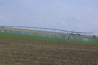
We followed some very quiet secondary roads, not far from the US border.
This is an area where all the locals wave at you - whether they know you or not!
Some, err, most all of the land was a bit on the flat side!
 But, as we soon came to discover, it was definitely - antelope country! No telephotos were available, so there are no photos, but in almost every field in some areas were a couple of antelope. I theorized that many of the females had left their herds to avoid predators and have their young. And we did see a few that appeared to be newborns.
Some of the areas near rivers had a lot of irrigation evident, with various types of sprinklers doing duty in the fields.


I think the big teepee was near Medicine Hat, along the highway.

We stopped at a cemetery pretty much in the middle of nowhere. It was the Pendant D'Oreille cemetary, with a large area and relatively few graves marked. A large stone listed pioneers in the area.

I found the following reference to it in another blog of the 'Midwesterner'
from Milk River, Alberta, we'd come past two cemeteries set out on the prairie. Still within sight of the Sweetgrass Mountains, we had stopped at the Pendant D'Oreille Cemetery where a large marker read: "In memory of the pioneers who settled this area and found their last resting place on the plains of Pendant D'Oreille." There were twenty-six names carved into the monument, twenty-six lives. The earliest: 1848-1917. The latest: 1902-1982.

 We eventually reached Cypress Hills Provincial Park, which is actually an Interprovincial Park, that straddles the boundary between the provinces of Alberta and Saskatchewan.
For information on the Saskatchewan side click here!
 Cypress Hills is:
the highest point in Canada between the Rocky Mountains & Labrador (maximum elevation - 1466 metres above sea level); the Cypress Hills are unique in that they were not glaciated during the last ice age; the park's montane environment is an oasis of mixed & lodgepole pine forests in the midst of the Canadian prairies; the park features a wealth of plant & animal life, including 14 orchid species.
That said, there is a LOT more relief to the terrain here in the park, than what we had been driving through.
 This is actually much more of a hill than it appears in the photo - even for someone more used to the Rocky Mountains.
 We checked out the large map on the roadside and checked out a few of the camping options, and finally decided to camp at Reesor Lake. We were getting short on time for the return trip, and as a result, will have to save any exploration of the Saskatchewan side for a future trip.
 On the way home we tried to avoid the main highways so turned off the Trans Canada just past Redcliff, and took secondary road 524 due west towards home. We stopped in at a small recreation site to cook up some supper. From there we just kept heading generally west before coming back through Bragg Creek.
All this meant it was a late arrival back home in the mountains. Yet another couple Parks to tick off the list!
Back at home, I struck up conversation with an RV'er in Lake Louise, who turned out to be a full timer, originally from Florida where he 'graduated' from work about 5 years ago. When I told him that we had just been to Writing-on-Stone, he told me that he had just done so as well - and blogged about it to boot.
You can check out his blog - and report on WoS at Roving Reports by Doug P
You can also read about his travels through the areas I call home!
Dang it. Back to work for a few days!
It could be worse though.
 'Work' involves keeping an eye on wildlife - like these two grizzly bears, whose photo I took through my spotting scope.
No comments:
Post a Comment