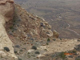
You can see that the road is a bit of a challenge, so I was a bit surprised in the morning to see this albeit small semi-trailer going up these switchbacks!
 A couple of corners above where I was camped, the tracks indicated that at least one outside dual had been rather hanging over the edge of the cliff! Yikes.
 Here's another shot of the drop off.
 Up, and up goes the road.
 The view looking back off the mesa, to the road we had approached on the previous night.
 Near the top, there was a wide spot and a viewpoint, so I stopped and put on the coffee and had some breakfast.
 It was pretty much vertical looking over the fence.
 After driving further, it was evident that some vehicles had not made the corner at some time in the past; intentionally or otherwise?
 Zoom in on this one and you should see at least two car carcasses.
 When the top of the mesa is finally reached, the road resumes it's normal look and even pavement again. But a side road to Muley Point beckoned me, and it was a worthwhile sidetrip out to the very end of the mesa. There is another goat trail like 4x4 road visible on the ledge way below the rim.
 Some of the rocks at top had sheared off in completely flat chunks.
 There was easy access and free camping areas all around. This is all part of the Cedar Mesa area administered by the BLM. There are innumerable options for hiking, driving, and camping both road accessible and back country.
 There are also ruins and rock art left by prehistoric peoples in the area.
The photo below shows another section of the 4x4 road on the ledge below. This is not the road I had followed on the approach.
 You can drive almost anywhere on the bare rock.
 Or just sit and enjoy the view - and the flying demonstrations by ravens and hawks making use of the updrafts along the cliffs.
 It would have been a great spot to enjoy the sunset, but unfortunately it was morning, and I had to make a few miles yet.
 No one fell off a cliff during the making of this photo.
 Onward toward Moab!


