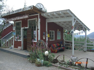
After parking the camper and walking across a foot bridge, we rode shuttle vans up from McCarthy to the abandoned mine site at Kennecott.The very rich copper deposit was discovered in 1900, which required the construction of 196 miles of railroad to service the mine, leading to the coast at Cordova.
The mine has been abandoned since 1938, but was taken over by the National Park Service in 1998, and they are attempting to restore or stabilize some of the buildings on site.
There was a large flood in recent history that damaged many of the structures and a bridge.
Some of the bunkhouse accommodations for workers at the mine.
A (stabilized) rail car loading area.
One of the huge ore processing buildings built on a steep hillside.
Some pretty incredible buildings and heavy equipment, especially for that era.
A view of the edge of the mine property, looking up towards the Kennicott glacier. They meant to name the mine after the glacier, but mis-spelled it as Kennecott!
Even though it was the end of July, because of the proximity of the glaciers, it was fairly cool around the mine site.
But, not too cool for this bumble bee!
Some of the historic vehicles and shacks on the way back down to the quaint (putting it mildly) village of McCarthy - next.
Tuesday, September 29, 2009
Sunday, September 27, 2009
After the growling Grizzly wake-up call on July 31st we continued on to Chitina (at left on the map below) and got on the 60 miles of gravel road on the way to McCarthy, the Kennecott mine, and Wrangell-St.Elias National Park
Almost immediately upon entering the road, there was a large number of fish traps operating on the river. I presume they were all first nations harvesters.
A distant shot of the traps (click on any photo for a larger view).
And a closer shot of the traps, and the related shacks, RV's and vehicles on the gravel flats of the river.There were a number of impressive bridges along the road, all originally built as a railway link to the Kennecott mine.
Some, like this one, are now used by vehicular traffic.
At 238 feet, it is rather high.
You don't want to drive off this one!
Others, are extensive railroad trestles, some of which were routinely washed out each spring by the flood waters.
Finally, we reached McCarthy (just across the river), and trail heads for hikes into Wrangell - St. Elias National Park.
We had to walk across this bridge, then pay for a shuttle van to take us the 6 or so miles up to the abandoned Kennecott mine - which is now administered and being restored by the National Park Service.
The huge glaciers of the National Park are visible from miles away.
Up closer to the glaciers near the Kennecott mine site, the valley appears to be a mile wide; a jumble of ice covered in gravel and rock.
Next, the Kennecott mine.
Wednesday, September 23, 2009
Not far into the US we fueled up at $3.72/gallon for diesel for the trip into Tok. In Tok, I managed to find some wi-fi to check e-mail and some coverage for my Roger's cell phone - which was useless all over the Yukon.From Tok, we turned south on the Tok cutoff road - which was another experience in permafrost road building - and re-building - and re-building!
We stopped at historic Gakona roadhouse and lodge, one of the few remaining original roadhouses in Alaska.
It was early afternoon, but we stopped in at the Trapper's Tavern and tested some of the local beers with Becca.
It was a very rustic and authentic looking pub - with lots of fishing photos and other memorabilia on the walls.
Alaskan White Ale was my favourite.
From the junction at Glennallen (named after two US Army explorers, Glenn and Allen!) we took the Richardson highway south for a ways, then turned off back east towards Chitina. Down a little bush trail we found a secluded riverside camp spot.
I wandered about a bit in the evening, and spotted some movement out in the river but could not be sure what it was. I thought it was possibly a grizzly, but the glimpse was too short.
I went back for my binoculars, but nothing more was seen.
That is, till morning when during breakfast we heard some very near sounds of a disturbance. Sure enough, there was a sow grizzly and cub just out on the river flats having a bit of a disagreement! I took some photos through the camper window, but none really showed the bears. So we had to settle for a shot of the cat out for a morning walk.
We were following the Chitina river eastward.
The road would lead us down about 60 miles of gravel to the town of McCarthy, and then the historic Kennecott mine.
Monday, September 21, 2009
After crossing back into the Yukon on the Haines Highway, the route followed Highway 3 north to Haines Junction. Once again, we fueled up in Haines Junction and then continued north on Highway 1 towards Kluane lake.
At the south end of the lake, a new bridge was being constructed over the Slims river.
We stopped in at the Parks Visitor centre (Kluane National Park Reserve)- which sported solar panels and windmills for power, but the doors were locked.
It looked like great sheep terrain in the surrounding mountains.
The silty waters of the river mouth contrasted sharply with the green waters of Kluane Lake.
Sections of the road had been recently re-built, but were in good shape. Further north, past Destruction Bay and Burwash Landing, the permafrost got the better of the roads, and the roller coaster began again!
We stopped at a small lakeside pull off near Beaver Creek, and considered spending the night, but it was still early, and it was a bit close to the main road.
There were some 'attack ducks' that came to investigate us, as well as some swans swimming in the lake. So we carried on towards the US boundary.
We did go past the Canadian customs station at the Beaver Creek airport, then found a side road and a comfortable gravel pit to play some frisbee and spend the night!
lat 62.409126 lon -140.852490
In the morning, we got to the US border, but there was no customs station in sight, just some joint Canada/US plaques and displays when crossing the line.
If you click on these photos, you can 'almost' read the text on them.
There was even a bench the straddled the line; half in each country. I wonder who paints it?
I think it was more a factor of being too far west rather than too far north, but my Sirius satellite radio pretty much stopped working around here. But it still worked better than the built-in XM radio in my GM truck - which seems to be stymied by any trees or mountains or anything to the south. Of course, on this particular trip the truck camper overhang covers the XM antenna on the cab roof, so it did not provide good service anywhere.
It was about 30 miles before reaching US customs, and the smoke from area forest fires began to limit the views. The roller coaster ride continued from the roads built over melting permafrost.
Next on the radar - Tetlin and Tok, Alaska
At the south end of the lake, a new bridge was being constructed over the Slims river.
We stopped in at the Parks Visitor centre (Kluane National Park Reserve)- which sported solar panels and windmills for power, but the doors were locked.
It looked like great sheep terrain in the surrounding mountains.
The silty waters of the river mouth contrasted sharply with the green waters of Kluane Lake.
Sections of the road had been recently re-built, but were in good shape. Further north, past Destruction Bay and Burwash Landing, the permafrost got the better of the roads, and the roller coaster began again!
We stopped at a small lakeside pull off near Beaver Creek, and considered spending the night, but it was still early, and it was a bit close to the main road.
There were some 'attack ducks' that came to investigate us, as well as some swans swimming in the lake. So we carried on towards the US boundary.
We did go past the Canadian customs station at the Beaver Creek airport, then found a side road and a comfortable gravel pit to play some frisbee and spend the night!
lat 62.409126 lon -140.852490
In the morning, we got to the US border, but there was no customs station in sight, just some joint Canada/US plaques and displays when crossing the line.
If you click on these photos, you can 'almost' read the text on them.
There was even a bench the straddled the line; half in each country. I wonder who paints it?
I think it was more a factor of being too far west rather than too far north, but my Sirius satellite radio pretty much stopped working around here. But it still worked better than the built-in XM radio in my GM truck - which seems to be stymied by any trees or mountains or anything to the south. Of course, on this particular trip the truck camper overhang covers the XM antenna on the cab roof, so it did not provide good service anywhere.
It was about 30 miles before reaching US customs, and the smoke from area forest fires began to limit the views. The roller coaster ride continued from the roads built over melting permafrost.
Next on the radar - Tetlin and Tok, Alaska
Subscribe to:
Posts (Atom)